Kenshar enterprises
We are lovers of nature especially
wetlands, endangered species, birds, reptiles and mammals
We are keen on issues related to
environment in a world with no keen interest
Our mission: save endangered species
and threatened habitats
Our vision: To conserve holistically
Our objectives:
1. to be champions of
conservation based on well researched ideas
2. To bring all stakeholders together
for a more inclusive approach
3. To enlighten the community on
dangers of species extinction and habitat destruction
Our motto: 1. stewards of the victim
2. Safe to be safe
3. Inform to empower against
ignorance
4. Steward the targeted
Our core values: honesty and service
driven
Sharing without discrimination
Positive nurturing
We organize events and generate concepts and idias and sell

The Forests of Nandi
These are the North Nandi Forest, the South Nandi Forest and
the North Tinderet Forest. All are important reserves and refuges for
plants and animals, many of them endangered species.
The North Nandi
Forest and the South Nandi Forest are particularly important in that
they are a unique mid-altitude ecosystem transitional in composition
between the
equatorial forests of central Africa (Congo type --- of which the
Kakamega Forest is the last surviving remnant in East Africa) and the
afro-montane forests of central Kenya. Both were gazetted as “Trust
Forest” in 1936; but have reduced in size, by about 20%, since that time
due to excision of land for settlement and the planting of tea bushes
and exotic trees.
About 80% of the forest reserves are closed-canopy at the 30 – 35m
level, but with the heads of the tallest trees projecting to 40m or more
above the ground. Dominant species include species of Croton, Prunus, Albizia, Syzgium, Celtis and Drypetes with an undergrowth of Acanthus and Brilliantaisia.
Walking here is wonderful and camping in a forest clearing or glade a
most rewarding experience --- particularly for the nature-lover; and
most particularly for the knowledgeable nature-lover. All bird-watchers
will be on the look out for Turner’s Eremomela (south forest), Chapin’s
flycatcher (north forest) and other rare species such as the Red-chested
Owlet and Golden-crowned Woodpecker. But, even in their absence, old
favourites such as Hartlaub’s Turaco, Cinnamon-breasted Bee-eater,
Yellow-spotted Barbet and the Black-and-white-casqued Hornbill will be
there to brighten the day
Koitalel Samoei Arap Turgat Memorial

This
memorial is also a mausoleum and a museum. It is situated in Nandi
Hills town, just across the main road from the District Commissioners
Office and Post Office.
The mausoleum houses the remains (except
the skull) of Koitalel who was the spiritual leader (orkoiyot) of the
Nandi when their land was being invaded by the British. How he was
assassinated in 1905 and the treatment of his brothers is grim but
fascinating history.
More uplifting is the story of how the British officer
responsible later came to regret his act, asked for forgiveness and
instructed his son to return the orkoiyot’s ceremonial sticks –--which
were stolen at the time --- to Kenya.
About Us KENSHAR ENTERPRISES
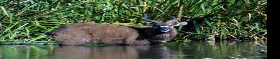
Kingwal Swamp

This extensive swamp is crossed by the main Eldoret – Kapsabet
highway between Kosirai and Chepteret. It is fed mainly by the Keses
river flowing in from the east and drained by the Kingwal river flowing
out to the west. It is said to have the largest population in the world
(about 140) of the endangered Sitatunga --- a semi-aquatic antelope with
webbed feet that allow it to walk on soft mud.
Unfortunately, the
likelihood of seeing Sitatunga, even with the assistance of local
guides, is small (approaching zero in the middle of the day) as they are
extremely shy creatures; indeed their very survival depends on their
secretiveness and distrust of human beings. They spend most of the day
in the water, much of it completely submerged with only their muzzles
above water, and come out at night to feed on grass and soft reeds.
The swamp is also home to a variety of birds. While at the swamp, ask your guide about the Kiplolog water springs.If you would just like a nice walk and a nice view of the region and do not want to go too far from Eldoret, try
Ndalat Hill.

Cross the Sosiani River and drive south, out of Eldoret, on the C39.
After only a few kilometers, turn right (west) onto the D288 and pass
Rivatex Factory. After 25 km you will reach Ndalat shopping centre where
your vehicle can be parked.
The hill is 2196m high, which is only about 130m higher than Eldoret,
so it is not really a challenge to reach the top; but, its open, grassy
slopes are steep in places and can be slippy, especially after rain.
The local community are very friendly and will even keep you company on
your hike.

Chepkiit Waterfalls
These
falls on the Kipkaren River are impressive in the rainy season. The
surrounding open woodland provides beautiful picnic sites.
Driving from Eldoret, pass the Moi International Airport and then the
Kipkaren River bridge and dam (prominent on the left). After a short
distance, turn right onto a dirt road and drive for about 3 km. Leave
your car and walk the remaining distance, about 1 to 1½ km, to the river
bank.
If you arrive early in the morning, you may be fortunate
enough to experience the rainbow formed by the morning sun refracting
from the water droplets of the falls.

Bird-lovers will not be disappointed; the cliffs, hanging rocks and
indigenous trees are home and hunting-grounds for a variety of species,
including Augur Buzzard, Grey Heron, Red-billed Hornbill, Red-cheeked
Cordon-bleu and Cliff Chat.
Be careful when clambering on the rocks. “Chepkiit" means “view from afar” and is a warning about how treacherous the rock surfaces can be.
 The
lick is actually a spring of alkaline "soda water" which emanates from
rocky ground and then descends as small waterfalls over rocks. It is
surrounded by unique vegetation and indigenous forest and close by there
are caves that can be explored. It is located near Lessos and can be
reached via the Eldoret – Kesses –Lessos route or the Kapsabet –Nabkoi
highway.
The
lick is actually a spring of alkaline "soda water" which emanates from
rocky ground and then descends as small waterfalls over rocks. It is
surrounded by unique vegetation and indigenous forest and close by there
are caves that can be explored. It is located near Lessos and can be
reached via the Eldoret – Kesses –Lessos route or the Kapsabet –Nabkoi
highway.
Nandi Hills Tea Plantations

From
a distance they appear as a gently undulating sea of green. Closer, one
sees the regular rows of bushes that produce the famous black tea that
is unrivaled in quality throughout the world.
Most of the tea estates
date from the colonial era and were carved out of the vast indigenous
forests. Many of the estates have, within their borders, special, even
unique, sites that they may make accessible to the general public.
Usually permission must be obtained and a small fee paid.
For example SIRWA CAVES, part of Kibabet Tea Estate,
has been developed into a beautiful picnic site and nature trail. The
deep caves and an impressive waterfall make a day out here memorable.
Prior arrangements should be made with Eastern Produce Company (Kenya)
before visiting. The EPCK offices are in Nandi Hills town.
Keben Springs Kiplolog
The springs
consist of a large number of variously-coloured up-wellings of water
that bubble to the surface of a swamp. The water is alkaline, perhaps
slightly carbonated, and, most definitely, quite tasty ---- but it is
doubtful if any proper chemical analysis has ever been done
Athletics Training Centres
Athletics is the main
sport in this region as it has propelled many to stardom and economic
independence. The reservoir of athletics talent is huge and you will
never fail to see athletes training along the roads, urban and rural,
especially early in the morning.
With prior arrangement, one can visit the International Olympic Committee / IAAF High Altitude Training Camp
and meet, and possibly join, both local and international athletes
training in the camp. Accommodation may be available on advance request;
contact the camp administrator.
From Monday to Saturday, one can
visit the Kipchoge Keino Stadium in Eldoret or the Chepkoilel Campus
(Moi University) training ground and watch Kenya's mid- and
long-distance athletes do speed training from 8.30 a.m. to 11 a.m.
There
are many small athletics training camps in the region that have
produced, and continue to produce, world-beating champions in track,
road races, marathon and cross country.
Golf Club
Golf
clubs in the region are purely members’ clubs and, generally, admit
non-members only when introduced and signed-in by a member or when an
individual is from a reciprocating club. However, in some cases,
temporary membership or day membership can be obtained. Within the Nandi
and Uasin Gishu region, there are two golf clubs: Nandi Bears Club in
Nandi Hills and Eldoret Club (both with 9-hole courses).
Opened in 1928, the Nandi Bears Club
gained its name from a legend from the Nandi community of a fierce
animal called Kerit, an animal resembling a bear and believed to target
the heads of its victims. It is further believed that the Nandi
spiritual leader, Koitalel Arap Samoei, was murdered next to the club.Set
high up on hills, the club offers beautiful vistas of the Nyando Plains
to the south and the Tinderet Hills to the east and endless, rolling
fields of tea. Due to the golf course's thick fairways and hilly
terrain, it definitely turns out to be very challenging to play on.
Eldoret Club, started in 1924, is located in a
serene and tranquil part of Eldoret town. The golf course measures 6649
yards. Other facilities the club provides for members include
accommodation, swimming, squash, tennis, badminton, and snooker. The
club aims to promote social interaction between people of different
backgrounds and gradually, over time, expand the facilities its members
can enjoy.
Canoeing at Lessos Dam 
The Nandi Escarpment 
It is a very roughly L-shaped geophysical boundary that is also a
socio-political dividing line. The vertical (N-S) line of the L
separates Nandi District from Kakamega District and the North Nandi
Forest from the Kakamega Forest. The horizontal (W-E) line of the L
separates Nandi from Kisumu and Kericho Districts. Within the angle of
the L, and stretching far back, is the South Nandi Forest; from which
flows the mighty Yala River. The Yala drops down to the plains below at
the weakest and lowest part of the escarpment ---- near Serem (the angle
of the L).
Many of the most interesting tourist attractions are located along
the escarpment; they include Bonjoge Reserve, the Nandi Rock, Sheu
Morobi, Sarongai and Tagessia hills.
For those adventurous at
heart, there are many places to descend and ascend the escarpment. One
of the most challenging and interesting is to climb from the sugar
plantations near Miwani to the top of the Nandi Rock. It will be an
unforgettable experience clambering over rocks and squeezing
through crevices you may doubt you can pass.

The Nandi Rock
This,
is the most prominent rock formation along the whole length of the
Nandi (Nyando) Escarpment, is a 30 minute walk from the KWS post at
Kaptumek. It is of great cultural significance to both the Nandi and Luo
and is a marker of the escarpment boundary between the tribes.
On the plains immediately below is one of the locations where barter trade took place between the two.
Branch
off the main highway (D291) at Kabujoi onto a murram road that passes
St. Peter Clavers School. Pass a left branch to Kimwaren and Miwani
(after 5 km); reach Maraba (further 2 km) where one enters a terrain of
rounded rocks and boulders, greatly various in shape and size; descend a
hill on a stretch of old tarmac to reach a junction (further 2 km) and
take the right branch to Chepkobel (further 7 km). Continue straight on
to reach Kaptumek dispensary and the KWS post (further 3 km). Some
sections of the road, particularly the last, can be tricky when it rains
heavily.
It is good to report to the KWS rangers at Kaptumek, so
that they are aware of the size of your party and your plans. If the
rangers are busy with other duties and you want a good local guide, ring
Richard Kosgei (0700634110).and Edwin Ngetich
The walk to the Rock, over
coarse-grained boulders and low-growing vegetation in rich, black soil
is not very challenging and soon one reaches rock ledges offering
magnificent views across the sugar plantations of the Nyando plains
towards South Nyanza, Lake Victoria and the shining buildings of Kisumu
city. The clearest views are early in the morning; the most beautiful
and memorable at sunset after a hot, sunny day. To the east and west the
escarpment stretches away into the middle distance. Most of the
boulder-strewn landscape to the west is part of Bonjoge National
Reserve.
A number of caves, large and small, can be visited. They
are home to a variety of animals, including bats, lizards and hyrax,
and make a convenient refuge for humans caught by the rain.The very top of the rock can be reached via a short (30m)
chimney, but should be tackled only by the experienced climber with
proper equipment.

Bonjoge National Reserve
Bonjoge is a designated national reserve of 21 km2
area, located on the undulating uplands atop the Nandi Escarpment, only
15 km north of Kisumu. It was a fertile area of great biodiversity,
with rivers, swathed in riverine woodland, flowing down to the Victoria
Lake Basin; but, in recent times, underwent exploitation and depletion
by human activities. It is now to be protected and restored through the
agency of the Kenya Wildlife Service.

Even
though, in large part, the millions of stones, rocks and boulders that
litter the landscape greatly outnumber the trees, it is still fine
country for walking and camping. Bird life is still abundant,
particularly in the remaining patches of forest and open-glade
grassland. Animals include Olive Baboons, Vervet , Colobus, Red-tailed
and De-brazza’s monkeys, Bush Duiker, Bush Pig, Aardvark, Genet Cat and
jackal.
It is best to access Bonjoge through the Kaptumek
entrance. Follow the route as described for the Nandi Rock and report to
the KWS post. You will be directed to go back 1 km and take a left turn
(west) onto the access road. After 7 km you will leave your vehicle and
proceed on foot for a further 1 km to reach the boundary of the
reserve.
Other entrances (“Gates”) are Kajulu (14 km from Kisumu) and Kesengei
(10 km south of Serem) but they are not recommended for use as
entrances in the near future. Anyway, Katumek offers the added
attraction of a visit to Nandi Rock.There is no accommodation in or near Bonjoge.Whether on a day excursion or a longer hiking/camping safari, be
prepared for rain. Even the local people will tell you Bonjoge rain is
especially heavy and exceptionally wet.
Sheu Morobi

This is a steep and overhanging cliff, perhaps 300 m high,
located between two hills covered by thick forest, on the Nandi
Escarpment. It is regarded with awe and fear by some locals, since, in
times past, very old people would, believing themselves to be useless,
jump to their deaths here. For some, the leap was not a matter of
choice; elders exceeding 100 years in age and women with illicit
pregnancies would be taken there and given a little push.Sheu Morobi means
“we go for ever”. For those choosing to make use of it in daytime,
their last view will certainly be beautiful if not memorable: the
expansive plains and lake of Nyanza with the misty, green hills of the
Kericho highlands in the background. At night, those same hills are a
distant, opalescent shimmer in the moonlight and the Morobi cliffs a
black abyss at one’s feet.
Those cliffs are said to offer good rock climbing. If you are
experienced (and don’t mind walking on old bones !) it might be worth a
visit ----- but check it out before you bring the ropes and pitons as
locals are not familiar with the qualities of rock a climber would be
looking for. You will have to walk in from the sugar plantations.
To get to the top of Morobi, drive 15 km from Nandi Hills, on the Kapsimotwo road, to Chematich village.
Visitors
should ask the local people about all the legends and get proper
directions. Some, perhaps not all, locals will be happy to speak to
strangers.
If the informant seems cooperative, ask also about “Daraja ya Mungu” ----another source of scary legends
 The
springs are in a wetland near Tulon Trading Center in Nandi District.
Turn off the Eldoret-Kapsabet road at Chepterit trading center and head
east on a murram road. Tulon is reached after 8 km. Continue for a
further 3 km and then turn right and follow a dirt road for about 5 km.
The last section can be particularly troublesome when it rains, because
it slopes down to the springs across black swamp soil. You are advised
to bring boots or gum boots and use a 4WD vehicle.
The
springs are in a wetland near Tulon Trading Center in Nandi District.
Turn off the Eldoret-Kapsabet road at Chepterit trading center and head
east on a murram road. Tulon is reached after 8 km. Continue for a
further 3 km and then turn right and follow a dirt road for about 5 km.
The last section can be particularly troublesome when it rains, because
it slopes down to the springs across black swamp soil. You are advised
to bring boots or gum boots and use a 4WD vehicle.

